Safe Routes to School (SRTS) in 9 Google Maps Layers
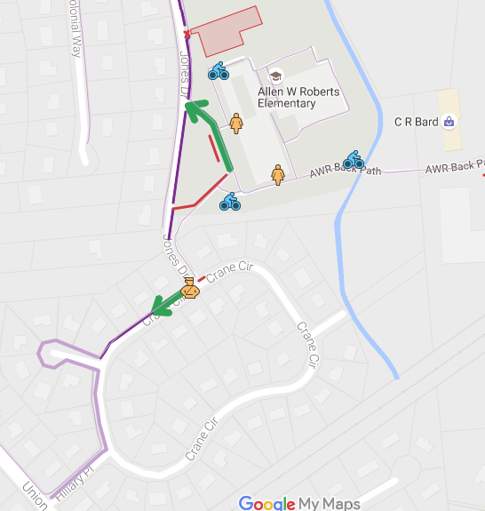
 Using Google Maps layers to interactively display Safe Routes to School greatly aided our community’s efforts to reduce school related traffic and improve safety and helped us win a large grant. In order to support families with kids at multiple age groups we include our elementary, middle and high schools on one view of Google My Maps with the following layers:
1. Drop & Go Locations
A safe and convenient way to drop off or pick up your children (or walk with them) at marked locations around the perimeter of school.
Thick bright green lines indicates where parents should drive their cars, drop their kids and go. These include a front entrance, a back or side entrance and designated safe locations that are involve kids walking for a minute or two. Drop & Go’s are:
- along a sidewalk,
- often in site of both the school and a crossing guard,
- lead directly to a supervised school entrance
- encourage car traffic to avoid bottlenecks.
2. Crossing Guards
Seeing the crossing guards on a map makes it much easier to plan routes to school, a friend’s house and an after school location. Click on the icon to see that guard’s hours. For example, afternoons only, school day times 7:45 – 8:40 a.m. 2:55 – 3:45 p.m.
3. Bike Racks
Blue bike icons show easily accessible bike racks. With the tremendous success of our Walk and Roll to School program the schools have been adding and moving bike racks.
4. Park & Walk
These dark purple lines along sidewalks show where parents usually park and walk to pick up our children after school.
5. Park & Wait
These light purple lines along sidewalks show Park & Wait suggestions. They are especially helpful if you’d like to come later and have your older kids walk to your car.
6. Don’t Park or Drop
Parents, please do not park or drop your kids off where there is a thin red line. These might be teacher parking spaces, certain businesses, private school parking lots, etc. As improvements are rolled out, using Google Maps layers greatly enhances communication because you know you have the latest version online.
7. Route of Travel
We used a medium green line to mark the direction of travel. Route of Travel encourages parents to drop kids safely along a sidewalk and channel the flow of cars away from existing bottle necks. As an added benefit they also direct the flow of kids toward existing crossing guards. Sometimes, these are reinforced with homemade signs as we try out new patterns.
8. Student Entrance to school
We marked open entrances with a yellow teacher icon similar to the crossing guard. It helps shift traffic from the front drop off and entrance to a back or side entrance with a Drop & Go. To find out when a student entrance is open and a teacher is stationed there click on the icon. For example, 8:15 to 8:30 am.
9. Edit underlying Google Maps
As you find errors in the map details of your neighborhood, you can submit edits directly to Google Maps. For example, use your local knowledge to add names, paths, sidewalks and footbridges.
To speed up the approval process for your edits, log in to Mapmaker with your Google account, enlist other locals to review each others edits and leave explanatory comments for Mapmaker reviewers.
Set access permissions for your Google maps layers
We made 2 versions of our Safe Routes to School map. In order to access to the more sensitive version of the map you must have a link. For example, parents and guardians can see our town’s maps only after logging in to the school or PTA/PTO web site. Eventually, we also created a public version that we share in our town Facebook group etc. Exporting Google Maps layers enabled us to easily create a “public” version without any sensitive information.
While the Interactive version of our map was created by a couple of parents, our “Green Team” involved all of the major stake holders, especially each building principal, police and PTA members. Edit authority includes a school district member, a policeman and two parents.

1 Response
[…] schools, Borough, police, PTA’s and TransOptions. Creating interactive maps using Google Maps, completing nomination forms. STEMshoots.com was created to ease. NJ SRTS documentation […]